Résultats de la recherche

Carte

Choisir carte: | | Téléchargement Centroids / Boundaries / Carte (pdf)
Le matériel présenté sur ce site web, et en particulier les cartes et l’information territoriale, est tel qu’il apparaît dans les données disponibles et n’implique en aucune manière l’expression d’une opinion quelconque de la part du Secrétariat de la Convention de Ramsar concernant le statut juridique de tout pays, territoire, ville ou zone, ou de ses autorités, ou concernant la délimitation de ses frontières ou limites.

Liste

  1. Aruban Burrowing Owl (Athene cunicularia arubensis) in front of its nest at Spaans Lagoen
    Juvenile Tricolored Heron (Egretta tricolor) at Spaans Lagoen.
    Lesser Yellowlegs (Tringa flavipes) at Spaans Lagoen.
    Regrowth of mangrove trees under the bridge which was constructed in 2016.
    Spaans Lagoen landscape
    The Spaans Lagoen wetland area with its desert scrub water catchment area in the back.
    English language information panel informing tourists about the rules and regulations at Ramsar site Spaans Lagoen.

    Spanish Lagoon

    • Pays: 
      Pays-Bas (Royaume des) (Aruba)
    • Date d’inscription: 
      23-05-1980
    • Numéro du site: 
      198
    • Publié depuis: 
      1 year(s)
    259 ha
  2. Information panel near the canal that connects Bubali Wetlands with the Caribbean Sea in the southwest of the site. The invasive water hyacinth can be seen in the background.
    The Bubali Wetlands are an oasis between urban areas and high rise hotels.
    Juvenile Little Blue Heron at Bubali Wetlands (Egretta caerulea).
    Roseate Spoonbill (Platalea ajaja)
    White Cheecked Pintails (Anas bahamensis)
    Black Skimmers
    Whimbrels (Numenius phaeopus)
    Shorebirds
    Great White Egrets (Ardea alba)
    The Bubali Wetlands are an oasis between urban areas and high rise hotels.
    Salina Cerca
    Salina Cerca
    Salina Druif
    Salina Malmok
    Salina Malmok
    Salina Palm Beach

    Western Wetlands

    • Pays: 
      Pays-Bas (Royaume des) (Aruba)
    • Date d’inscription: 
      10-11-2023
    • Numéro du site: 
      2528
    • Publié depuis: 
      1 year(s)
    392 ha
  3. Rules and regulations at the entrance of one of the site's beaches.
    The site encompasses Aruba's largest stand of mangrove forest.
    The tangle of mangrove trees and branches protects the coast from extreme weather events.
    One of the islets that is part of a chain of islands in front of the coast.
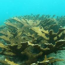
    Elhorn coral) Acropora palmata)
    Honeycomb cowfish (Acanthostracion polygonius) in sea grass beds (Thalassia testudinum and Zyringodium filiforme).
    False killer-whale (Pseudorca crassidens).
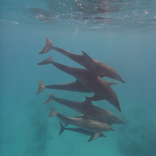
    The Atlantic spotted dolphin (Stenella frontalis) uses the site for refuge, birthing and nursery.
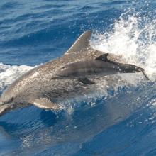
    The Rough-toothed dolphin (Steno bredanensis) uses the site for refuge, birthing and nursery.
    Several dolphin species, like Tursiops truncatus, can be observed close to the coast.

    South Coast

    • Pays: 
      Pays-Bas (Royaume des) (Aruba)
    • Date d’inscription: 
      10-11-2023
    • Numéro du site: 
      2526
    • Publié depuis: 
      1 year(s)
    3'975 ha
  4. Sunset at Nagi
    Osprey
    Pied Kingfisher
    Common Pochard

    Nagi Bird Sanctuary

    • Pays: 
      Inde
    • Date d’inscription: 
      11-10-2023
    • Numéro du site: 
      2545
    • Publié depuis: 
      1 year(s)
    206 ha
  5. Swans in Hyo-ko, cherry blossoms, and Gozu mountain range with remaining snow
    Flying for commuting
    Hyo-ko in a fine clear day
    Hyo-ko at sunrise

    Hyo-ko

    • Pays: 
      Japon
    • Date d’inscription: 
      30-10-2008
    • Numéro du site: 
      1842
    • Publié depuis: 
      1 year(s)
    24 ha
  6. Edithvale South Wetland

    Edithvale-Seaford Wetlands

    • Pays: 
      Australie
    • Date d’inscription: 
      29-08-2001
    • Numéro du site: 
      1096
    • Publié depuis: 
      1 year(s)
    261 ha
  7. Yunoko with autumn colour
    Yunoko in May with an angler
    Mt.Nantai in Senjogahara
    Eriophorum vaginatum in Senjogahara
    Autumn foliage in Odashirogahara
    Odashirogahara in autumn

    Oku-Nikko-shitsugen

    • Pays: 
      Japon
    • Date d’inscription: 
      08-11-2005
    • Numéro du site: 
      1553
    • Publié depuis: 
      1 year(s)
    260 ha
  8. North of lake Ammersee with Ampermoos
    South of lake Ammersee with the Natura 2000 area "Ammersee south shore and Raistinger meadows" and the nature reserve "Vogelfreistätte Ammersee Süd"
    View from the observation site at the western dike of the new Ammer across the so-called Binnensee to the Dießen Minster. Core area for wetland birds with shallow water zones, reed beds and a nesting raft for Common Terns. In the foreground, siltation zone resulting from the bursting of a dam at the
    Downstream area dammed by a beaver in the Ampermoos, the large river valley fen north of Lake Ammer

    Lake Ammer

    • Pays: 
      Allemagne
    • Date d’inscription: 
      26-02-1976
    • Numéro du site: 
      93
    • Publié depuis: 
      1 year(s)
    6'386 ha
  9. Aerial view of Lake Galenbeck

    Lake Galenbeck

    • Pays: 
      Allemagne
    • Date d’inscription: 
      31-07-1978
    • Numéro du site: 
      177
    • Publié depuis: 
      1 year(s)
    1'040 ha
  10. Ostufer der Müritz Luftbild
    Ostufer der Müritz

    Eastern shore of Lake Müritz

    • Pays: 
      Allemagne
    • Date d’inscription: 
      31-07-1978
    • Numéro du site: 
      172
    • Publié depuis: 
      1 year(s)
    4'974 ha

Pages

Stats


Exports

Exportation d’informations sur les Sites Ramsar

Pour une liste résumée de tous les Sites Ramsar en format pdf, cliquez ici.

Générer des rapports sur un choix de Sites Ramsar

Vous pouvez générer un rapport à partir des filtres choisis, soit en pdf, soit en xls. Le rapport classera les résultats par noms de sites à moins que vous n’ayez choisi une autre variable de tri.

Pour les pdf, vous pouvez choisir d’inclure le texte d’introduction de chaque site ou seulement les données principales dans un rapport plus court.

Afin de recevoir la liste des sites Ramsar que vous avez sélectionnés, veuillez SVP nous fournir votre courriel et entrer le texte que vous voyez dans l'image de vérification dans la zone de texte.

Une foi la liste créée, un courriel vous sera envoyé contenant le lien pour accéder au fichier. Cela ne devrait pas prendre plus de 10 minutes.