Resultados de la búsqueda
La búsqueda encontró 11 sitios Ramsar que abarcan 235,413 ha
- (-) Remove ¿Se dispone de fotografía?: Sí filter ¿Se dispone de fotografía?: Sí
- (-) Remove Fecha de designación: 1976 filter Fecha de designación: 1976
Mapa
Los materiales presentados en este sitio web, particularmente los mapas y la información territorial, se proporcionan tal cual y según están disponibles a partir de los datos de los que se dispone y no implican la expresión de opinión alguna por parte de la Secretaría de la Convención de Ramsar respecto de la condición jurídica de ningún país, territorio, ciudad o zona, ni de sus autoridades, ni respecto de la delimitación de sus límites o fronteras.
Lista
-
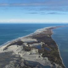
Farewell Spit
-
País:Nueva Zelandia
-
Fecha de designación:13-08-1976
-
Número del sitio:103
-
Publicado hace:33 year(s)
11,388 ha -
-


Karkinitska and Dzharylgatska Bays
-
País:Ucrania
-
Fecha de designación:11-10-1976
-
Número del sitio:114
-
Publicado hace:3 year(s)
147,557 ha -
-


Lake Barrea
-
País:Italia
-
Fecha de designación:14-12-1976
-
Número del sitio:131
-
Publicado hace:4 year(s)
241 ha -
-
 et le Fanel (à droit du canal) avec les zones humides et la lagune.")
 .")
Fanel et Chablais de Cudrefin
-
País:Suiza
-
Fecha de designación:16-01-1976
-
Número del sitio:79
-
Publicado hace:8 year(s)
1,155 ha -
-


Lake Starnberg
-
País:Alemania
-
Fecha de designación:26-02-1976
-
Número del sitio:94
-
Publicado hace:0 year(s)
5,652 ha -
-


Kyliiske Mouth
-
País:Ucrania
-
Fecha de designación:11-10-1976
-
Número del sitio:113
-
Publicado hace:3 year(s)
44,904 ha -
-


Ismaninger water reservoir with fish ponds
-
País:Alemania
-
Fecha de designación:26-02-1976
-
Número del sitio:92
-
Publicado hace:1 year(s)
986 ha -
-


Donauauen & Donaumoos
-
País:Alemania
-
Fecha de designación:26-02-1976
-
Número del sitio:90
-
Publicado hace:0 year(s)
7,067 ha -
-


.")
Lower Inn between Haiming and Neuhaus
-
País:Alemania
-
Fecha de designación:26-02-1976
-
Número del sitio:96
-
Publicado hace:0 year(s)
1,846 ha -
-


Lake Chiemsee
-
País:Alemania
-
Fecha de designación:26-02-1976
-
Número del sitio:95
-
Publicado hace:1 year(s)
8,231 ha -